Creation of a Service for Tailor-made Training in Remote Sensing: Tree of Beads

First model of tree of beads in remote sensing basics
People interested in economic or thematic exploitation of spatial data and Copernicus services often struggle to engage in the mastering of remote sensing techniques for their own purposes. Progress in the exploitation of Copernicus data is thus slowed down by the difficulty in understanding the domain's fundamentals. Indeed, even if complete training courses in remote sensing are numerous, they are aimed at initial and complete training, usually with a technical and/or engineering level. These are not dedicated to the contractor with poor or absent bases in RS, but strong operating incentives, especially contractors from the digital economy.
This action proposes the creation of a customized training service in remote sensing. On the basis of multi-level skill mappings, individuals would choose a specific training objective and automatically discover the required theoretical and technical skills. Each of them will be connected to online and/or face-to-face training. Finally, this service will help people develop their own personal journey.
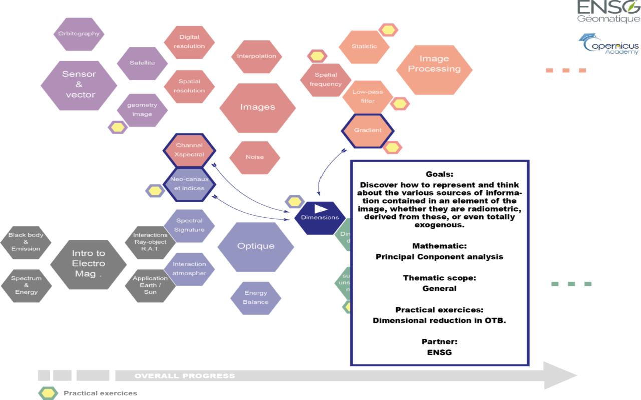
Learning is a nonlinear process. As a result, this project will design a network of singular and fundamental notions in remote sensing (each making the subject of an at most 30-minute lesson). Each fundamental notion is a “Bead”. A bead possesses a short description and a link to the theoretical training. It is also connected to practical exercises to develop the technical aspects of the training. The beads are grouped by topics (e.g.: the bead “Black body” in the topic “Introduction to electromagnetism”).
Finally, each bead is connected to the pre-requisites needed for understanding. In this way, it is easy for each learner to create his own personal unique training tree, and discover the tight relationship between theory and practice.
This proposal could be connected to any contributors of FPCUP creating a catalogue of formation. We stress that the EO4GEO Project is looking for Partners to join an exercise focusing on the field of the Earth Observation / Remote Sensing and further developing the Geographic Information scope in order to develop the Body of Knowledge (BoK) for Geographic Information and Earth Observation. A network of experts will be soon gathered within the scope of EO4GEO. This will be a good entry point to develop our skill repository in remote sensing.
Outputs and Results
- Production of a base of the different beads, the connection between them, and the practical exercises related to Copernicus data exploitation; it will be validated with some expert from CNES
- Effective implementation of the service, with connections to existing resources
- Action aims at reaching at least 2 member states with the training/information activities and at producing at least 5 communications in different EU languages, while referring to all 6 Copernicus services.